

Indigenous Peoples Atlas of Canada

คำอธิบายของIndigenous Peoples Atlas of Canada
The Indigenous Peoples Atlas of Canada, produced by The Royal Canadian Geographical Society in partnership with the Assembly of First Nations, Inuit Tapiriit Kanatami, the Métis Nation, the National Centre for Truth and Reconciliation and Indspire, the Indigenous Peoples Atlas of Canada shares the stories, perspectives, voices and history of the Indigenous Peoples of Canada. It includes historic and contemporary maps and explores themes of language, demographics, economy and culture. Important topics such as treaties and residential schools are covered in-depth, as well as the contributions of Indigenous Peoples, their oral traditions and land-based knowledge.
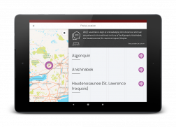
A territorial or land acknowledgment is a centuries-old tradition among Indigenous Peoples, and is also today an important part of Canada's reconciliation process — it is becoming common for non-Indigenous people to make such acknowledgments at public events and in schools.
ชนเผ่าพื้นเมือง Atlas แคนาดาผลิตโดยสมาคมภูมิศาสตร์แคนาดาในความร่วมมือกับสภาแห่งชาติครั้งแรกที่เอสกิโม Tapiriit Kanatami ที่Métisประเทศชาติศูนย์แห่งชาติเพื่อความจริงและความสมานฉันท์และ Indspire, ชนเผ่าพื้นเมือง Atlas แคนาดาหุ้นเรื่องราว มุมมองเสียงและประวัติศาสตร์ของชนพื้นเมืองของประเทศแคนาดา ซึ่งจะรวมถึงแผนที่ประวัติศาสตร์และร่วมสมัยและสำรวจรูปแบบของภาษาประชากรเศรษฐกิจและวัฒนธรรม หัวข้อสำคัญอาทิเช่นสนธิสัญญาและโรงเรียนที่อยู่อาศัยได้รับความคุ้มครองในเชิงลึกเช่นเดียวกับการมีส่วนร่วมของชนพื้นเมืองประเพณีในช่องปากของพวกเขาและความรู้ที่ดินตาม
น่านหรือที่ดินรับรู้เป็นประเพณีเก่าแก่หมู่ชนพื้นเมืองและยังเป็นวันนี้เป็นส่วนสำคัญของกระบวนการปรองดองของแคนาดา - มันจะกลายเป็นเรื่องธรรมดาสำหรับคนที่ไม่ใช่พื้นเมืองเพื่อให้กิตติกรรมประกาศเช่นประชาชนในเหตุการณ์และในโรงเรียน


